
Location-aware applications have known huge success over the last few years and geographic data have been used extensively in a wide variety of ways. Meanwhile, there are numerous places of interest out there, such as shopping malls, airports, restaurants, museums, transit stations and for most of them their addresses are publicly available on the Web. Therefore, you could use DEiXTo (or a web data extraction tool of your choice) in order to scrape the desired location information for any points of interest and then postprocess it so as to produce geographic data for further use.
Yahoo! PlaceFinder is a great web service that supports world-wide geocoding of street addresses and place names. It allows developers to convert addresses and places into geographic coordinates (and vice versa). Thus, you can send an HTTP request with a street address to it and get the latitude and longitude back! It's amazing how well it works. Of course, the more complete and detailed the address, the more precise the coordinates returned.
In the context of this post, we thought it would be nice, mostly for demonstration purposes, to build a map of Thessaloniki museums using the Google Maps API and geo-location data generated with Yahoo! PlaceFinder. The source of data for our demo was Odysseus, the WWW server of the Hellenic Ministry of Culture that provides a full list of Greek museums, monuments and archaeological sites.

So, we searched for museums located in the city of Thessaloniki (the second-largest city in Greece and the capital of the region of Central Macedonia) and extracted through DEiXTo the street addresses of the ten results returned. At the picture below you can see a sample screenshot from the "INFORMATION" section of the Folk Art and Ethnological Museum of Macedonia and Thrace Odysseus detailed webpage (from which the address of this specific museum was scraped):


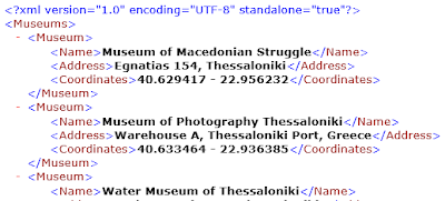
After capturing the name and location of each museum and exporting them to a simple tab delimited text file, we wrote a Perl script harnessing the Geo::Coder::PlaceFinder CPAN module in order to automatically find their geo-location coordinates and create an XML output file containing all the necessary information (through XML::Writer). Part of this XML document is displayed right below:

After having all the metadata we needed in this XML file, we utilized the Google Maps JavaScript API v3 and created a map (centered on Thessaloniki) displaying all city museums! To accomplish that goal, we followed the helpful guidelines given in this very informative post about Google Maps markers and wrote a short script that parsed the XML contents (via XML::LibXML) and produced a web page with the desired Google Map object embedded (including markers for each museum). Finally, the end result was pretty satisfying (after some extra manual effort to be absolutely honest):


This is kind of cool, isn't it? Of course, the same procedure could be applied in a larger scale (e.g. for creating a map of Greece with ALL museums or/and monuments available) or expanded to other points of interest (whatever you can imagine, from schools and educational institutions to cinemas, supermarkets, shops or bank ATMs). In conclusion, we think that the combination of DEiXTo with other powerful tools and technologies can sometimes yield an innovative and hopefully useful outcome. Since you have the raw web data at your disposal (captured with DEiXTo), your imagination (and perhaps copyright restrictions) is the only limit!
No comments:
Post a Comment